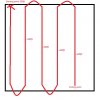
Is there any way to change the altitude of a survey when planning it out? I want to take a survey of a sloped property. So I used the mission planning part of solex, made a take off point, a waypoint to fly to the start of the survey and then put in a survey. I then finish with a return home/land. I selected the area I wanted to do the survey. The starting point is 200ft, however the ending point would be about 800ft (maintaining a 200ft AGL at each point). I did try to import the elevation data from google, but that just seems to have switched the entire survey's height to the end height. I'm not sure if there's a way to put in way points during the survey to change elevation, or if I should just break down the survey into separate surveys, one for each elevation change.
I have attached a highly sophisticated piece of art that demonstrates what the heck I'm on about. ( I have not signed it in order to prevent people selling copies of my amazing artwork on Ebay.)
I have attached a highly sophisticated piece of art that demonstrates what the heck I'm on about. ( I have not signed it in order to prevent people selling copies of my amazing artwork on Ebay.)