Is there anything I can read or watch to learn more about this?These things work by calculating how far away each satellite is, measuring that and using the differences to correct the assumed position. At startup it has to synchronize its clock(s) to the satellite system(s) clock(s) and it does that by moving gates around time values near those predicted by the calculated ranges. If it is near where it was shut down and the satellite ephemeris data is fresh it should be able to lock up pretty quickly. If you shut it down in LA and bring it back up in Sydney 6 mos later it will have to search code by code (each satellite has its own) over a wide range of delays until is can lock to one and then download the Nav Message to update the satellite ephemerides. There are many strategies for this but the almanac download takes a long time.

M8N GPS Bestar BN-880 setup
You are using an out of date browser. It may not display this or other websites correctly.
You should upgrade or use an alternative browser.
You should upgrade or use an alternative browser.
Sure, lots but where to send you! There is a website that sells books on this stuff at GPS/GNSS Engineers | NavtechGPS. FWIW I learned about GPS from the ION Red Books but that was 35 years ago when it was in its infancy and a lot has changed. We had GPS/GLONASS receivers then but it took 2 guys to carry them.Is there anything I can read or watch to learn more about this?
The books listed on that site are pretty technical. They are intended for engineers and scientists for the most part.
HDOP is the sum of the first two diagonal elements of the GDOP matrix. The GDOP matrix is the inverse of the product of the transpose of a matrix with its (un transposed) self which matrix is 4 columns by one row for each visible satellite. The fourth column is all ones and the three others contain the direction cosines from receiver to the satellites with respect to each of the three coordinate axes.
If you can read that paragraph you will have no problem with any of them. If that paragraph is totally incomprehensible you will have a problem and might better start with a video such as this one which should lead you to others. The problem I have with the videos is that all the ones I have found imply, or say in so many words, that location is determined precisely by finding the point of intersection of three spheres centered on three satellites. In fact location is done by finding the point in time and space whose mean squared distance from a set of spheres (1 for each of the visible satellites) is minimum.

OK...thanks for all the info. There's some really awesome stuff in there, I've learned a lot! But admittedly I'd still like the "GPS for dummies" explanation lol.
So to be clear...the number of satellites doesn't really matter. What matters is the HDOP number? Is that correct?
And one thing I'm still not clear on. If I upgrade to the M8N GPS unit....will the HDOP number on my screen be accurate?
So to be clear...the number of satellites doesn't really matter. What matters is the HDOP number? Is that correct?
And one thing I'm still not clear on. If I upgrade to the M8N GPS unit....will the HDOP number on my screen be accurate?
I don't know if it will be accurate but I'm not sure it matters. Solo won't go into FLY mode on startup until HDOP is below 2.0 (generally).OK...thanks for all the info. There's some really awesome stuff in there, I've learned a lot! But admittedly I'd still like the "GPS for dummies" explanation lol.
So to be clear...the number of satellites doesn't really matter. What matters is the HDOP number? Is that correct?
And one thing I'm still not clear on. If I upgrade to the M8N GPS unit....will the HDOP number on my screen be accurate?
While flying, I've never seen it get higher.
I did the upgrade recently and get faster lock and more satellites- generally 20, so I think it is worth it.
So, if the HDOP number is not accurate, does that affect the accuracy or flying ability of Solo?
Yes, HDOP is more important than the number of satellites but as a general statement the more satellites you can see the better the HDOP. At the same time it is possible to have 4 satellites with better (smaller) HDOP than 10 satellites that are unfortunately placed. But there are other reasons for wanting more visible satellites. If you have good HDOP with 7 but fly in front of a building which hides 2 the system may decide it has lost GPS because it wants at least 6 for RAIM (in which the residuals for each satellite are examined and any that is larger than some threshold amount is assumed to be in trouble and is removed from the solution.So to be clear...the number of satellites doesn't really matter. What matters is the HDOP number? Is that correct?
We have to assume that the receiver manufacturer knows how to compute HDOP given that it is, as the paragraph in my last pose shows if you know the lingo, really quite simple. The receiver spits this info out over its Tx pin to the SOLO computer upon request (or continuously - I don't know) and the SOLO displays it to us. So yes, it will be accurate but at the same time we need to recognize that position_uncertainty = DOP*pseudo_range_error so that if this receiver sees more satellites (and thereby delivers lower HDOP) but has poorer signal processing which results in higher pseudo_range_error we could wind up with worse position uncertainty. I think that scenario quite unlikely.And one thing I'm still not clear on. If I upgrade to the M8N GPS unit....will the HDOP number on my screen be accurate?
Of greater concern to me is that my just delivered SOLO has a GPS module with a 6 wire harness with the 5th and 6th pins not labeled the same as the 5th and 6th pins on the M8N. I question whether the latter is still a drop in replacement for the 7.
I did the upgrade recently and get faster lock and more satellites- generally 20, so I think it is worth it.
When did you grt your SOLO? Did the stock GPS module have 4 or 6 wires? If so, did you connect all 6 of the M8N wires?
Depends. In mathematical terms HDOP is the first two diagonal elements of the 4 x 4 matrix (A_T*A)^-1. The correction to the DR position are (A_T*A)^-1*A_T times the residuals which makes it pretty plain that if you can't compute GDOP properly you can't update the position. In practice the updates are usually computed by a Kalman filter which does the matrix math implicitly rather than explicitly.So, if the HDOP number is not accurate, does that affect the accuracy or flying ability of Solo?
It is possible to take HDOP and the residuals and compute an error ellipse or circle (as is done on your iPhone). This would be, IMO, more valuable information than HDOP.
When did you grt your SOLO? Did the stock GPS module have 4 or 6 wires? If so, did you connect all 6 of the M8N wires:
Depends. In mathematical terms HDOP is the first two diagonal elements of the 4 x 4 matrix (A_T*A)^-1. The correction to the DR position are (A_T*A)^-1*A_T times the residuals which makes it pretty plain that if you can't compute GDOP properly you can't update the position. In practice the updates are usually computed by a Kalman filter which does the matrix math implicitly rather than explicitly.
It is possible to take HDOP and the residuals and compute an error ellipse or circle (as is done on your iPhone). This would be, IMO, more valuable information than HDOP.
I got mine in mid August. The stock had 6 wires. When installing the M8N only the Tx, Rx, (+), and (-) are connected.
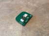
See attached photo of the stock GPS:
Attachments
Thanks. Mine has the 3VC (or whatever it is) pin and a 6th with an equally cryptic label. Clearly whatever 3VC is you aren't using it apparently without problem. The addition of 3VC and the other pin tell me that something has been changed and I'm afraid to swap out the stock part until I learn what this is about. Whatever the functions enabled by those other two wires are I wouldn't have them.
In an experiment I just did SOLO found and locked to 9 satellites in a minute and a half. An earlier check with a Garmin receiver at the same location showed that 10 satellites were visible with the 10th weak and it locked to them in a little over a minute. So it looks as if perhaps the GPS performance has been improved but I would like to have the Glonass birds as well in the event of shadowing of some of the GPS birds by trees, buildings, rocks etc.
I'm editing this to add that acquisition has a couple of steps. First the receiver must lock to the spreading/timing code and then it must receive the nav message which contains the ephemeris data, clock correction data and an almanac for the complete constellation. The receiver must have at least the first 3 sub-frames before the satellite can be used and this data is transmitted every 30 seconds (at a low 50 bps). If there are any bit errors then another 30 seconds goes by before another copy of those 3 subframes can be received. I noted that my SOLO code locked to 4 birds within a few seconds (display of 4 Satellites but in red) but took longer to get to the point where it was ready to fly (locked to 9 and Nav message received for all 9).
I'll also add that there are strategies to speed up lock on. For example, if the receiver stores all the ephemeris data, gets code lock and does a trial solution with the stored ephemeris data and finds the solution good it knows that the ephemeris is valid and doesn't have to wait 30 sec for those subframes to come around again.
Last edited:
Interesting test results:
Today I conducted 2 flights to test the wifi card mod I installed in the Solo controller yesterday, but the GPS information was the most interesting.
#1: Test of stock antenna. Climbed to 300' altitude. Solo made it to 3288' before RTL kicked in, double the range before the mod. I was able to quickly regain control and fly back.
20 sats, 1.1 HDOP, -66dB. Here's interesting part #1:
I landed Solo manually on the landing pad it took off from, but the Solo app showed Solo landed 20' away and its altitude was 13' above ground!
#2: Test of FPVLR v.2- flew to 300 ' altitude. Made it to 3637' distance before RTL kicked in- no increase in range.
19 sats, 1.3 HDOP, -67dB, 2 bars still showing.
Interesting part #2:
I was never able to regain contact or control again- despite that, Solo returned, landed and stopped the props by itself. It landed only 1' away from the landing pad it took off from!
The app screen on my Nexus 7 remained "frozen" with the data it had when contact was lost, so I don't know what the "indicated" altitude was when Solo landed.
So, what does all this mean? If the GPS data was off, how did Solo land itself with such accuracy? I have no idea- hopefully somebody else does. @ajdelange are you there?
If you installed 500 mw cards your theoretical range would increase by sqrt(500/300) = 1.29 i.e. by 29%Interesting test results:
Today I conducted 2 flights to test the wifi card mod I installed in the Solo controller yesterday, but the GPS information was the most interesting.
#1: Test of stock antenna. Climbed to 300' altitude. Solo made it to 3288' before RTL kicked in, double the range before the mod. I was able to quickly regain control and fly back.
If you installed 700 mw cards your theoretical range would increase by sqrt(700/300) = 1.53 i.e. by 53%
The fact that you got better than this most probably means that you weren't getting the full theoretical range you should have been before the mods. There are a whole host of reasons why this might have been the case.
This kind of behavior is quite typical of GPS. The inherent accuracy of a system aided by DGPS or WAAS is on the order of meters. As time progresses the satellites move around, multipath reflections come and go, the clock in the receiver drifts and so on. If HDOP is good and all the satellite pseudo range error is good with WAAS enabled we might expect a 50% CEP of 2 meters. This means the receivers reported position is inside a circle of radius 2 m centered on the true locaton 50% of the time. The implication is that it is inside a circle of 4 meter's radius 97% of the time and outside that circle 3% of the time. If you have a smart phone the circle is displayed (though I have no idea as to whether it is the 50% circle or the 98% circle) and you can watch it grow, shrink and move around even as you stand still. So, assuming that you locked before takeoff, I assume that things changed enough to move the GPS/GLONASS estimate of the location of the takeoff point by 20'.20 sats, 1.1 HDOP, -66dB. Here's interesting part #1:
I landed Solo manually on the landing pad it took off from, but the Solo app showed Solo landed 20' away and its altitude was 13' above ground!
Note that VDOP, the Vertical Dilution of Precision, is worse than HDOP by about a factor of 3. This is because there are no visible satellites beneath you. Thus altitude errors from GNSS are greater that horizontal errors. SOLO therefore uses pressure altitude (a barometer) to make the determination that it is near the ground but apparently displays the GNSS altitude. There are implications here if you lock on a hill and have to autoland in a valley and is one of the reasons why a sonic/optical altimeter would be a great addition (CJI has this).
Well, a little but not what you should have gotten. Those antennas are supposed to have about 10.5 db gain over isotropic from which we must deduct 3 dB for circular to linear coupling loss and compare to about 4 dbi for the stock antennas giving perhaps 3.5 dB effective gain over the stock. That should give you a theoretical range increase of 10^(3.5/20) = 1.49624 or about 50%. Again, there are many reasons why you may not have realized this. You need to be aware that the 10 dB gain is attained by focusing the radiation into a beam. You must keep the antennas pointed in the direction of the SOLO to realize its benefit.#2: Test of FPVLR v.2- flew to 300 ' altitude. Made it to 3637' distance before RTL kicked in- no increase in range.
.
It appears that what happened here is that your telemetry back to the controller froze so that you were not being kept up dated but that does not mean GPS/GLONASS was lost. With 19 satellites we would hope that that would be the case. Were GPS/GLONASS lost SOLO would not have been able to find its way home and would have gone into manual mode.19 sats, 1.3 HDOP, -67dB, 2 bars still showing.
Interesting part #2:
I was never able to regain contact or control again- despite that, Solo returned, landed and stopped the props by itself. It landed only 1' away from the landing pad it took off from!
The app screen on my Nexus 7 remained "frozen" with the data it had when contact was lost, so I don't know what the "indicated" altitude was when Solo landed.
So, what does all this mean? If the GPS data was off, how did Solo land itself with such accuracy?
So while apparently you didn't lose GNSS you did lose the data link and that's troublesome. I's send the logs off to 3DR
Thanks @ajdelange!
My questions/concerns in no particular order:
1. Before changing out the GPS card, I hit the return to home button and allowed Solo to return and land by itself on several occasions. I wanted to see how close it would land to its take-off spot and it was always within about 5', sometimes closer.
If the HDOP on the M8N is truly not as accurate, would it affect the landing accuracy? Did Solo just get lucky on test 2? If I had allowed Solo to land itself on test 1, would it have had the same accuracy as it did on test 2?
2. Slightly off the topic of this thread, the wifi card upgrade in the controller clearly helped the stock antennas distance and after losing signal I was quickly able to get it back.
The FPVLR didn't see a gain even though I was aiming them at Solo the entire time. (As best I could tell at that distance) Never regaining control was a 1st and unnerving experience. Never happened with this antenna before. I was using my Nexus 7 so I could record the screen. I haven't used it as much as my iPad mini 3 but have never had a problem.
Was the system lockup caused by the Nexus (I have heard reports of the app freezing but don't know if this is what I experienced). Even if the app crashes the controller should still be able to control Solo.
Is it possible the wifi card (Mikrotik R11e-2HnD, 800 mw) doesn't "get along" with the FPVLR?
I'll try repeating the test tomorrow in a different area with my iPad mini to see what happens.
- Joined
- Jan 9, 2016
- Messages
- 85
- Reaction score
- 18
May i ask you where you got that mikrotik wifi card? I looking for it aswellThanks @ajdelange!
My questions/concerns in no particular order:
1. Before changing out the GPS card, I hit the return to home button and allowed Solo to return and land by itself on several occasions. I wanted to see how close it would land to its take-off spot and it was always within about 5', sometimes closer.
If the HDOP on the M8N is truly not as accurate, would it affect the landing accuracy? Did Solo just get lucky on test 2? If I had allowed Solo to land itself on test 1, would it have had the same accuracy as it did on test 2?
2. Slightly off the topic of this thread, the wifi card upgrade in the controller clearly helped the stock antennas distance and after losing signal I was quickly able to get it back.
The FPVLR didn't see a gain even though I was aiming them at Solo the entire time. (As best I could tell at that distance) Never regaining control was a 1st and unnerving experience. Never happened with this antenna before. I was using my Nexus 7 so I could record the screen. I haven't used it as much as my iPad mini 3 but have never had a problem.
Was the system lockup caused by the Nexus (I have heard reports of the app freezing but don't know if this is what I experienced). Even if the app crashes the controller should still be able to control Solo.
Is it possible the wifi card (Mikrotik R11e-2HnD, 800 mw) doesn't "get along" with the FPVLR?
I'll try repeating the test tomorrow in a different area with my iPad mini to see what happens.
And am i must change the wifi card both at the controller and the drone? Or can i just change the one in the controller? Bcs its quite difficult to access the one in the drone
I got it at www.readytoflyquads.com. I only changed the controller - lots of folks do that.May i ask you where you got that mikrotik wifi card? I looking for it aswell
And am i must change the wifi card both at the controller and the drone? Or can i just change the one in the controller? Bcs its quite difficult to access the one in the drone
As I noted in an earlier post the HDOP is very easy to calculate to the point that I simply cannot imagine the manufacturer of a GPS receiver being unable to calculate it correctly and even if he were the usual implementation of GPS today is in a Kalman filter where the HDOP is not explicitly calculated. HDOP is only there to show the user that he has acceptable (< 2) geometry. You cannot blame the failure of your SOLO to return to the same spot on faulty GDOP computation. As I said in the earlier post having it return 20' away from where it locked is unusual (should happen less than 5% of the time) but quite possible. You need to do this experiment multiple times. It should return to within a meter or so about half the time. The other half of the time it can be expected to return more than a meter away and occasionally a few meters away.My questions/concerns in no particular order:
1. Before changing out the GPS card, I hit the return to home button and allowed Solo to return and land by itself on several occasions. I wanted to see how close it would land to its take-off spot and it was always within about 5', sometimes closer.
If the HDOP on the M8N is truly not as accurate, would it affect the landing accuracy? Did Solo just get lucky on test 2? If I had allowed Solo to land itself on test 1, would it have had the same accuracy as it did on test 2?
I am more concerned in your particular case with the fact that SOLO's 3VC wire is no longer connected to anything. As I have no idea what that wire is for I have no idea what to expect when it is disconnected but one would suspect something in the GPS functionality.
You should see appreciable increased range with these antennas. Apparently you got as far as 3637' before things went south but you had an RSSI of -67 at that point so perhaps you didn't see improved range because the app froze. I would try again with another phone/pad with which you have found the app to be more stable.2. Slightly off the topic of this thread, the wifi card upgrade in the controller clearly helped the stock antennas distance and after losing signal I was quickly able to get it back.
The FPVLR didn't see a gain even though I was aiming them at Solo the entire time. (As best I could tell at that distance) Never regaining control was a 1st and unnerving experience. Never happened with this antenna before. I was using my Nexus 7 so I could record the screen. I haven't used it as much as my iPad mini 3 but have never had a problem.
Yes, you would think so but the controller, the tablet and the drone are all on the same network with the controller being the 'hot spot'. If the Nexus tied up the hotspot somehow it could prevent communications with the SOLO.Was the system lockup caused by the Nexus (I have heard reports of the app freezing but don't know if this is what I experienced). Even if the app crashes the controller should still be able to control Solo.
No, that's not likely. It is more likely that the card isn't seeing eye to eye with the computer in the SOLO. For example, the WIFI card is reporting RSSI to the computer but there is no standard definition of RSSI. Unless the definition of RSSI is exactly the same in the replacement card as it was in the stock card the SOLO will not interpret it properly.Is it possible the wifi card (Mikrotik R11e-2HnD, 800 mw) doesn't "get along" with the FPVLR?
I'll try repeating the test tomorrow in a different area with my iPad mini to see what happens.
Whenever you 'improve' something by retrofitting new parts you take a risk. It is best, therefore, to swap out one thing at a time and thoroughly test the system before changing out anything else. OTOH the behaviours you have seen could be normal GNSS performance related and a fluke hang of the Nexus. Additional experiments are the best thing you can do at this point.
I got it at www.readytoflyquads.com. I only changed the controller - lots of folks do that.
Ah. The SOLO can hear the controller but the controller can't hear the SOLO. While I do not know the details of any of the WiFi protocols we can be certain that it is set up such that if the SOLO sends a packet to the controller and does not get an acknowledgement back it will send it again and again until it does or it times out at which point I'm sure it declares 'link lost' and switches to RTH mode. This may or may not be a factor in what you say yesterday but to fully realize the improved range you would need to increase the transmit power at the SOLO end too.
Ahh- that makes sense. Changing the card in the Solo is a big job- probably why most guys don't.Ah. The SOLO can hear the controller but the controller can't hear the SOLO. While I do not know the details of any of the WiFi protocols we can be certain that it is set up such that if the SOLO sends a packet to the controller and does not get an acknowledgement back it will send it again and again until it does or it times out at which point I'm sure it declares 'link lost' and switches to RTH mode. This may or may not be a factor in what you say yesterday but to fully realize the improved range you would need to increase the transmit power at the SOLO end too.
Regarding the altitude issue, I remembered that Solo uses a barometer to judge altitude- not GPS I'm told. That further confuses the issue.

Thanks for your reply- it is very helpful.As I noted in an earlier post the HDOP is very easy to calculate to the point that I simply cannot imagine the manufacturer of a GPS receiver being unable to calculate it correctly and even if he were the usual implementation of GPS today is in a Kalman filter where the HDOP is not explicitly calculated. HDOP is only there to show the user that he has acceptable (< 2) geometry. You cannot blame the failure of your SOLO to return to the same spot on faulty GDOP computation. As I said in the earlier post having it return 20' away from where it locked is unusual (should happen less than 5% of the time) but quite possible. You need to do this experiment multiple times. It should return to within a meter or so about half the time. The other half of the time it can be expected to return more than a meter away and occasionally a few meters away.
I am more concerned in your particular case with the fact that SOLO's 3VC wire is no longer connected to anything. As I have no idea what that wire is for I have no idea what to expect when it is disconnected but one would suspect something in the GPS functionality.
You should see appreciable increased range with these antennas. Apparently you got as far as 3637' before things went south but you had an RSSI of -67 at that point so perhaps you didn't see improved range because the app froze. I would try again with another phone/pad with which you have found the app to be more stable.
Yes, you would think so but the controller, the tablet and the drone are all on the same network with the controller being the 'hot spot'. If the Nexus tied up the hotspot somehow it could prevent communications with the SOLO.
No, that's not likely. It is more likely that the card isn't seeing eye to eye with the computer in the SOLO. For example, the WIFI card is reporting RSSI to the computer but there is no standard definition of RSSI. Unless the definition of RSSI is exactly the same in the replacement card as it was in the stock card the SOLO will not interpret it properly.
Whenever you 'improve' something by retrofitting new parts you take a risk. It is best, therefore, to swap out one thing at a time and thoroughly test the system before changing out anything else. OTOH the behaviours you have seen could be normal GNSS performance related and a fluke hang of the Nexus. Additional experiments are the best thing you can do at this point.
Regarding the 3VC connection: the new GPS card has 6 connections and the 2 that are not used are for its compass. Don't know yet about the 3VC.
I went out yesterday and repeated the tests, this time with my iPad mini 3.
I basically got the same results except when contact was lost the iPad did not freeze up. I was able to reconnect and fly Solo back.
In checking the last 8 test flights and a few before I installed the M8N, I discovered that even when on the ground before takeoff, the displayed altitude was not the same on any 2 flights. It varied from 1 - 6 feet. I had never noticed it before but now believe it must be related to Solo's barometer.
During the last 8 flights, the weather changed rapidly during the day. On both days it was overcast in the AM and cleared up by about noon. (Test time was about 11:30 AM) each day. I think this could account for the varying altitudes before and after flight.
You're right that I should have done 1 upgrade at a time with testing in between.
So, for now, I'm good with the M8N upgrade and the wireless card. I may upgrade the wireless card in Solo after more flying.
Not sure what to do about the Nexus but for now I'm only going to use it for Tower missions (carefully).
Thanks for your reply- it is very helpful.
Regarding the 3VC connection: the new GPS card has 6 connections and the 2 that are not used are for its compass. Don't know yet about the 3VC.
I'm not concerned about the two wires on the 8N8 that are not used (compass). I am concerned about the two wires that used to connect to the stock compass card that are now not connected to anything. They were probably there for something. Does the stock card have a compass? Or barometer?
Good. Confirms that the link is basically good. Did you see any improvement is range with the circular antennas?I went out yesterday and repeated the tests, this time with my iPad mini 3.
I basically got the same results except when contact was lost the iPad did not freeze up. I was able to reconnect and fly Solo back.
It is entirely normal for atmospheric pressure to change enough to cause a barometric altimeter reading to change by that much in 15 minutes. There is a big discussion of this in another thread.In checking the last 8 test flights and a few before I installed the M8N, I discovered that even when on the ground before takeoff, the displayed altitude was not the same on any 2 flights. It varied from 1 - 6 feet. I had never noticed it before but now believe it must be related to Solo's barometer.
During the last 8 flights, the weather changed rapidly during the day. On both days it was overcast in the AM and cleared up by about noon. (Test time was about 11:30 AM) each day. I think this could account for the varying altitudes before and after flight.
Understand about the 2 mystery connections- don't know what they were used for yet. Nothing but GPS on stock card.I'm not concerned about the two wires on the 8N8 that are not used (compass). I am concerned about the two wires that used to connect to the stock compass card that are now not connected to anything. They were probably there for something. Does the stock card have a compass? Or barometer?
Good. Confirms that the link is basically good. Did you see any improvement is range with the circular antennas?
It is entirely normal for atmospheric pressure to change enough to cause a barometric altimeter reading to change by that much in 15 minutes. There is a big discussion of this in another thread.
No range improvement on circular antennas.
I have been following the other thread- good info!
Understand about the 2 mystery connections- don't know what they were used for yet. Nothing but GPS on stock card.
No range improvement on circular antennas.
I have been following the other thread- good info!
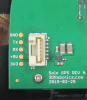
The 2 other connections don't go anywhere on the GPS board, the 3V3 testpoint on the GPS board is just that, a test point for the 3.3v LDO which supplies the u-blox. 5V comes from the Solo, goes to the 3.3V LDO.
On the Solo I can't find any connections to the 2 Mystery wires in the cable (orange & blue)
In the attached photo of the gps connector you can see that the 3V3 testpoint trace goes by the connector and the 5V trace goes to pin 1.
Attachments
Similar threads
- Replies
- 4
- Views
- 1K
- Replies
- 3
- Views
- 963
- Replies
- 1
- Views
- 2K
- Replies
- 0
- Views
- 1K