
So I just got my solo and have been using my iPhone 6s but want a bigger screen. I've read a bunch about iPad mini's but keep finding conflicting info on wi-fi only vs wi-fi +cell service. So far it seems that if you use a wi-fi only iPad mini you can't get the map view? I fly mostly out in the backcountry so don't have much need for a street map. Also wondering is there any other way to know what dirrection solo is facing if your not using a map? Say if its out to far to see and you loose reception and need to know what direction home is without using the go home feature?


You are using an out of date browser. It may not display this or other websites correctly.
You should upgrade or use an alternative browser.
You should upgrade or use an alternative browser.
- Joined
- Mar 21, 2016
- Messages
- 249
- Reaction score
- 75
Congratulations on your new Solo! I hope you enjoy it as much as we do.
Yes, if you get any device (iOS or Android) that does not already have a data plan, you won't get real time map updates. However, if you use a wifi only device, you can just cache it ahead of time while on wifi first before connecting to the Solo. If you don't need the map at all, you don't need to use it. You'll just see a floating pointer on a blank map. In your case, it should just suffice. Personally, I'd prefer a map at all times. What if you lost your Solo in a tree?
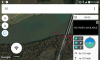
Regarding the direction, without the map view, no, but you can still achieve this with the cached maps above. In the Solo app you can swipe right from the left edge and you'll get a sidebar of a map with the direction your Solo is pointing. You can also get a heading in degrees using the Tower app. It looks like the image attached.
Fun tip: The Tower app can do all the above and tell you a rough idea of where the camera is pointed on the satellite map (along with the live feed). It is a feature called real-time camera footprint.
In my opinion, if you're going to push your Solo that far away to the point of losing signal, you really should just use the GPS assist. The Go Home feature is a really nice plus so long as you put the RTH height higher (but under 400ft)
Yes, if you get any device (iOS or Android) that does not already have a data plan, you won't get real time map updates. However, if you use a wifi only device, you can just cache it ahead of time while on wifi first before connecting to the Solo. If you don't need the map at all, you don't need to use it. You'll just see a floating pointer on a blank map. In your case, it should just suffice. Personally, I'd prefer a map at all times. What if you lost your Solo in a tree?
Regarding the direction, without the map view, no, but you can still achieve this with the cached maps above. In the Solo app you can swipe right from the left edge and you'll get a sidebar of a map with the direction your Solo is pointing. You can also get a heading in degrees using the Tower app. It looks like the image attached.
Fun tip: The Tower app can do all the above and tell you a rough idea of where the camera is pointed on the satellite map (along with the live feed). It is a feature called real-time camera footprint.
In my opinion, if you're going to push your Solo that far away to the point of losing signal, you really should just use the GPS assist. The Go Home feature is a really nice plus so long as you put the RTH height higher (but under 400ft)
Attachments
Last edited:
Congratulations on your new Solo! I hope you enjoy it as much as we do.
Yes, if you get any device (iOS or Android) that does not already have a data plan, you won't get real time map updates. However, if you use a wifi only device, you can just cache it ahead of time while on wifi first before connecting to the Solo. If you don't need the map at all, you don't need to use it. You'll just see a floating pointer on a blank map. In your case, it should just suffice. Personally, I'd prefer a map at all times. What if you lost your Solo in a tree?
Regarding the direction, without the map view, no, but you can still achieve this with the cached maps above. In the Solo app you can swipe right from the left edge and you'll get a sidebar of a map with the direction your Solo is pointing. You can also get a heading in degrees using the Tower app. It looks like the image attached.
Fun tip: The Tower app can do all the above and tell you a rough idea of where the camera is pointed on the satellite map (along with the live feed). It is a feature called real-time camera footprint.
In my opinion, if you're going to push your Solo that far away to the point of losing signal, you really should just use the GPS assist. The Go Home feature is a really nice plus so long as you put the RTH height higher (but under 400ft)
thanks for the info, I guess i'm not real sure how to cache a map? Could you tell me the steps to do that or point me in the right direction? I'm still not sure how much I will need to use the maps? Can you do all the smart shots with my phone and then just use a iPad mini wi-fi only when I want a bigger screen?
- Joined
- Mar 21, 2016
- Messages
- 249
- Reaction score
- 75
It's easier than you think. Connect your wifi only tablet to the Internet, click on the map and scroll around. It will load and automatically cache them.
As for all the smart shots, everything will work except for Follow Me mode if your device does not have a built in GPS.
As for all the smart shots, everything will work except for Follow Me mode if your device does not have a built in GPS.
What if I'm in the backcountry and there is no wi fi anywhere? So when I'm at home use my home wi-fi connection open the solo app and swipe left to open the map and it will save it to the iPad? Is it the solo app that caches the maps? Sorry if i'm not getting this yet. Also I tried some smart shots in 2.7k and it keeps giving me an sd card error? Anybody ever seen that?
- Joined
- Mar 21, 2016
- Messages
- 249
- Reaction score
- 75
Exactly that. I know it works for Android but I am assuming it works the same for your iPad.
In regards to the SD card error, try this:
https://gopro.com/support/articles/no-sd-or-sd-err-on-cameras-lcd
Also, make sure you have a fast enough card to keep up with the higher resolution. It's not obvious because all the different types of microSD cards look so much alike but actually perform differently.
You need a card with fast write speed (UHS-1) to take full advantage of the GoPro.
How to Identify Your microSD Card Class Rating
Thanks for the help Tamj I did find an article on caching maps on an iPad and they said its a little different and that the iPad just automatically saves them? Guess I have to decide which iPad to get. I did just do a test flight and changed my setting back to 1080 and the smart shots worked ok. So i'm going to bet like you said it might be my memory card which is a sandisk ultra class 1 card and I don't think its rated for 2.7k or 4k.
Well I decided of the iPad mini 4 wi-fi with cellular so I wouldn't have to worry about not having any of the smart shots or features. Tried it out real quick today and seems like it works pretty well. Will do some more testing tomorrow.
Using the Solo with the iPad Mini 2 (32Gb) Wi-Fi only, I also have an iPhone 6, but I needed the bigger screen. So before flying I connect my iPad Mini the internet via the device link using my iPhone 6. Open the Solo app on the iPad Mini, swipe left to open the map and scroll & zoom around the location. Then disconnect the iPad Mini from the iPhone and connect to the Solo Link Wi-Fi. Start-up the Solo and App on the iPad and all the maps are available, this works well. If I want "Follow Me" mode, I use the iPhone 6 with the controller.
Be safe and happy landings.........................
Be safe and happy landings.........................
- Joined
- Mar 21, 2016
- Messages
- 249
- Reaction score
- 75
Using the Solo with the iPad Mini 2 (32Gb) Wi-Fi only, I also have an iPhone 6, but I needed the bigger screen. So before flying I connect my iPad Mini the internet via the device link using my iPhone 6. Open the Solo app on the iPad Mini, swipe left to open the map and scroll & zoom around the location. Then disconnect the iPad Mini from the iPhone and connect to the Solo Link Wi-Fi. Start-up the Solo and App on the iPad and all the maps are available, this works well. If I want "Follow Me" mode, I use the iPhone 6 with the controller.
Be safe and happy landings.........................
You got it!
")
I'm on my iPad right now connected to wifi and cannot get satellite maps to come up, only street view see attached image.Thanks for the info. I did play around with the iPad Air wi-fi only and cache the maps ahead of time and did get it to work. I just decided to get the cell service on the mini since it was only a few bucks a month.
I cannot get a satellite view to come up. Also what's the point of the mission planner? That seems to do nothing. All I get is this screen, see attached. Again I'm just sitting on my couch connected to wifi. Is there more I need to do?
Attachments
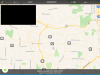
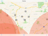
The mission planner has two functions. 1. Displays information about your area with regards to safety ATC and other restrictions. 2. Use the filter option to display the Satellite display, the mission planner sets the map display type in flight mode. The name of the flight planner is misleading and the documentation for this is not great.
The drone needs to be connected for the displays to work in Satellite mode, if no drone is connected, you will only get the standard map display.
This information is based on my experience with the Solo app.
Be safe and happy landings.....
The drone needs to be connected for the displays to work in Satellite mode, if no drone is connected, you will only get the standard map display.
This information is based on my experience with the Solo app.
Be safe and happy landings.....
- Joined
- Mar 21, 2016
- Messages
- 249
- Reaction score
- 75
The mission planner has two functions. 1. Displays information about your area with regards to safety ATC and other restrictions. 2. Use the filter option to display the Satellite display, the mission planner sets the map display type in flight mode. The name of the flight planner is misleading and the documentation for this is not great.
The drone needs to be connected for the displays to work in Satellite mode, if no drone is connected, you will only get the standard map display.
This information is based on my experience with the Solo app.
Be safe and happy landings.....
I find the part about the drone needing to be connected for satellite views to work correctly interesting.
On my Android devices they load just fine in Satellite view without even being on the Solo's network.
I have tried every combination with my iPhone6 and iPad min 2,
In the preflight map view on the home screen I Can use the filter option to set the map display type, but with the fly mode I only get the standard map, with drone not connected. I may be missing an option or setting, but I can not set the map type within fly mode, but with the drone is connect with GPS lock, the map display type changes to a Satellite view.
I must be missing something, or a option in fly mode.
The documentation for the app for iOS is not very good.
As I have stated, I'm using an iPad Mini 2 (wi-fi only) and the iPad works great, but after a few weeks I have missed the GPS functionality when using the Solo app, and since I would have to purchase a new more expensive iPad to get the GPS functionality and pay the monthly data connection to a cell network. So I purchased a Garmin GLO with Glonass & GPS sensor which connects to the iPad via Bluetooth, and I'm happy to report it works as expected. The Solo app now displays both location for the drone and Garmin GLO and all the GPS functions work, I purchased the Garmin GLO for $85.00 on Amazon. After a quick setup with a Bluetooth connect, it works.
You will still need to cache the maps for your area before flying, but this is a minor thing.
Be safe and happy landings.
You will still need to cache the maps for your area before flying, but this is a minor thing.
Be safe and happy landings.
Similar threads
- Replies
- 0
- Views
- 1K
- Replies
- 5
- Views
- 2K
- Replies
- 5
- Views
- 3K
- Replies
- 7
- Views
- 2K
New Posts
-
 Free Music / SFX Resource for Your Videos - Over 2000 Tracks
- Latest: Eric Matyas
-
-

-

-