I have conducted a direct aerial orthomosaic comparison between the GoPro Hero 4 Silver and the Canon s110 Powershot. Both cameras develop 12 Megapixel photos. The Canon s110 has a standard lens while the GoPro has a fisheye (wide view) lens.
Aim:
Determine which camera is best for aerial orthomosaic generation.
Method:
Compare orthomosaic imagery from two separate cameras having undergone identical process methodology.
Process methodology included
a) Flying two separate aerial surveys at identical height (80 m) and light conditions (overcast +- Noon), each using different camera for photo generation. Despite each having different focal length, each survey allowed for 70% image overlap.
b) Generation of separate orthomosaics using identical processing parameters by Agisoft Professional software.
Comparison Results:
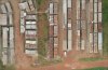
Canon s110:
Advantage: Imagery is of higher resolution and displays colours more vividly (colour contrast is more apparent).
Disadvantage: Orthomosaic distortion and image alignment becomes exponentially more distorted as distance increases away from vertical position of the survey. All orthomosaic area directly outside survey boundary should be ignored (deleted).
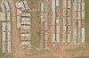
GoPro Hero 4 Silver:
Advantage: Orthomosaic distortion and image alignment far outside the survey area retains moderate accuracy.
Area of accurate orthomosaic is significantly larger (+- double area). Better option when conducting 3D volumetric analysis.
Disadvantage: Imagery is of lower resolution and displays colours less vividly (colour contrast is less apparent).
Results:
My suggestions for developing orthomosaics:
Use the Canon s110 only if your drone can cover the entire survey area with greater 70% photo overlap. All area beyond the vertical survey box should be ignored (not trusted).
Use the GoPro Hero4 only if your drone will have problems covering the full survey area. Area beyond the vertical survey box can be trusted with moderate accuracy.