Single Line Survey?

Joined
Oct 24, 2017
Messages
8
Reaction score
1
Location
North Carolina
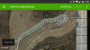
I need a little help. I am planning a street survey mission for a city street department. It is 1.6 miles of city street I want to capture.

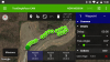
I have a 3dr solo and I just really need to fly the center of the road and take pictures so I get 60 to 70% picture overlap. I've used the survey feature in QGroundControl, Tower, and Solex with good results. Solex is easiest for me to geotag the pictures which will be important. However, I just need a "single line" survey. I don't need to make multiple passes, I only want to take a survey one picture wide.

I could drop waypoints and set the GoPro to take a picture every 2 seconds, but I'd like to have the camera triggered to get more precise and easier geotagging.

I feel like there is a simple solution and I'm missing it. Thanks for any assistance. - Seth

Screenshot from 2017-10-30 18-09-40.png
 
I've just recently mastered mission planner + geosetter, used tower and solex previously but the former option is by far the best in my opinion, and you can't beat using a laptop to make everything organised and less prone to errors. There's some good YouTube tutorials, about an hours worth and you should be able to get up and running, it was much easier than I had anticipated.
 
  • Like
Reactions: Saijin_Naib
GeoSetter Beta + Mission Planner for me as well. Tower functions solely as a telemetry display for me in-field. A touch of QGIS here and there as well ;)
 
Yes, that will be my next learning task, ween myself off google earth
50,000% worthwhile. QGIS is pretty phenomenal. Before you even dive into doing anything in QGIS, make your first task to organize the UI into something that makes sense to you. Button-shock made me shy of QGIS for a while. I turned everything off and then selectively turned on panels and toolbars as I needed them.

One of the main goals of the v3.x branch is to improve this first-start experience and reduce the barrier to entry by making the UI a bit more intuitive and less overwhelming.
 
I installed it a couple of years ago and it just looked liked the time I needed to invest to learn didn't warrant what I had to do at the time, but that's changed now
 
  • Like
Reactions: Saijin_Naib
Why do you want a 60 or 70% overlap on one pass? Usually that's for point cloud stuff. 25% work better? Mission Planner is great.
 
I feel like there is a simple solution and I'm missing it. Thanks for any assistance. - Seth
View attachment 7209
Closest I got was drawing a boundary polygon around a road and then running Auto WP with Grid and Corridor with 1M corridor spacing, but I still ended up with three passes.

I've emailed Michael Oborne about it.
 
You can do it in Tower easy as well. Just put a Camera Trigger WP right after the first WP of the flight line. Calculate the distance between photos and enter that number. When Im in the field and unsure of that number I just create a quick survey with the overlap I want and look at that number in the flight plan. Just takes a minute, otherwise I use the Adams Object Distance spreadsheet for calculating things out.
 
Thanks for the GREAT replies. I really appreciate all the assistance.

The suggestion of MissionPlanner and Geosetter seems like a good answer, but my laptop runs Ubuntu and these programs don't seem to run 100% on Linux. I can run MissionPlanner with mono, but it's not 100%. However, it does seem very powerful. I can't get geosetter to run on Linux at all.

Also, I appreciate the suggestion for QGIS. I want to learn more about this tool. I will take to heart the advice about turning off the extra windows and making a less intimidating GUI.

I did take some time after work to plan a quick test mission with Solex doing what David Boulanger suggested. This seemed to worked great. I'm not 100% sure if Solex is really ready for prime-time. It seems like there are still some issues with it. However, with my computer setup it works well for me. I've included some screen shots of the mission planning as well as the image geotagging.

I'm waiting for dronedeploy to stitch the images together. I'll post when done.

Also, after flying the test mission this afternoon I experimented with ACRO mode. You guys might be entertained with this short video (
To view this content we will need your consent to set third party cookies.
For more detailed information, see our cookies page.
).

Again, thanks and I hope one day I can help others on this forum like I've been helped. - Seth
 

Attachments

  • Screenshot_20171031-213936.png
    Screenshot_20171031-213936.png
    2.7 MB · Views: 22
  • Screenshot_20171031-214020.png
    Screenshot_20171031-214020.png
    1.8 MB · Views: 20
  • Like
Reactions: Saijin_Naib
If you are doing a 3D reconstruction, a single pass will NOT give you enough coverage for the dense cloud points. you need multi-pass with different angles
 
QUESTION??? How do you do all this and stay within FFA regulations? I'm at a loss, and would like to go this route, but I'm all little chicken. Does 400 ft, lOS,.flying over people, an flying restricted zones, etc. no longer mean any thing?
Bill
 
QUESTION??? How do you do all this and stay within FFA regulations? I'm at a loss, and would like to go this route, but I'm all little chicken. Does 400 ft, lOS,.flying over people, an flying restricted zones, etc. no longer mean any thing?
Bill
No idea in the states, but where I am, if you're a licensed RPA pilot, you can apply for permission in some urban areas as long as you have a parachute and then coordinate with authorities once you have the permit. So I guess it must be similar as the regs are almost a copy paste from the American regs
 
QUESTION??? How do you do all this and stay within FFA regulations? I'm at a loss, and would like to go this route, but I'm all little chicken. Does 400 ft, lOS,.flying over people, an flying restricted zones, etc. no longer mean any thing?
Bill
Do you have 107 license?
 
no I dont, but the regs seem to be pretty stiff even if you do. Saw where CNN only one to have exception to flying over people. If i'm in a remote area with no one around, I don't mind going over 400/ etc. Where are you going to fly in San diego, lA, San Fransisco even with a Lic.?
 
I've thought about how to perform this survey and still follow the FAA rules. The issues are flying over people and moving cars. I see two potential options.

One option is to just close the street for a few minutes. However, the challenge is all the side streets intersections would have to be closed or monitored too.

The other option I've thought of is to drive a truck along the street and keep the solo directly over the truck. Downside is the truck will be in the center of all the survey photos. If this were preformed early on a Sunday morning there is a good chance there will not even be any traffic it at least there will be minimal traffic.

The third option is to fly off center of the street and fly over house/buildings. However, there could be people in their yards and people/cars on the side streets. Does not seem like an acceptable solution.

And I do have my part 107 certificate.
 
no I dont, but the regs seem to be pretty stiff even if you do. Saw where CNN only one to have exception to flying over people. If i'm in a remote area with no one around, I don't mind going over 400/ etc. Where are you going to fly in San diego, lA, San Fransisco even with a Lic.?
In this case, you have no business flying the survey.
 
I've thought about how to perform this survey and still follow the FAA rules. The issues are flying over people and moving cars. I see two potential options.

One option is to just close the street for a few minutes. However, the challenge is all the side streets intersections would have to be closed or monitored too.

The other option I've thought of is to drive a truck along the street and keep the solo directly over the truck. Downside is the truck will be in the center of all the survey photos. If this were preformed early on a Sunday morning there is a good chance there will not even be any traffic it at least there will be minimal traffic.

The third option is to fly off center of the street and fly over house/buildings. However, there could be people in their yards and people/cars on the side streets. Does not seem like an acceptable solution.

And I do have my part 107 certificate.
Putting that into the public arena does none of us any good. Worldwide we are battling ever increasing regulations because of the actions of a few.
 

New Posts

Members online

No members online now.

Forum statistics

Threads
13,094
Messages
147,748
Members
16,058
Latest member
Gabriela