Or why I really need to find a sunshade for my Solo Controller.
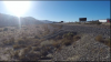
Went back out to Palm Springs, the windmill area off I-10 and Hwy 111, to try to do another windmill and train video. Unfortunately there wasn't enough wind to film the windmills and a freight train amazingly showed up just a few minutes after I arrived at the location.
Lots of bright sunshine and no sunshade.
As the last car went by, I decided to fly after it. I was flying at around 23 feet. I really couldn't see the screen that well but could follow by line of sight. At least for a hundred yards or so.
What I failed to consider was that the land was rising. About 523 feet out, Solo lost contact. Then it reconnected. Tried to return home, nothing. Pushed Fly button, said Solo needed a level surface.
It was gone. So I set off looking for it, at least an hour, nothing. At this point, I thought it was gone. It occurred to me that there might be another way to find it. I went back to the origin point and turned on my phone GPS and brought up a topo map(hike) app and went out exactly 1/10 of a mile, 528 feet exactly. After about 2 minutes, I found it at the base of the gravel incline going up to the train tracks, the bird luckily did not slide down under the dried brush. If it had, it would have been lost forever as they would not ever mow that, only a fire going through would expose the melted plastic to view.
Whew!
I looked for an unusual shape, black, and it stood out. Especially since the landing lights were on still. No damage to anything, even the camera or gimbal, and not a scratch on the body. Unbelievable! Of course, I had to fly it again, right there, to see if it was okay, and it was!
Here are a few still shots from the video taken.

Here the drone slipped through the edges of the tree.

Heading for impact, at speed.

Right before impact.

For want of a nail, er sunshade, all was almost lost. Next time, more altitude and attention to details, such as the topography down the flight path. And no more spur of the moment decisions, such as following the train, unless planned before hand.
Not much of a video editor but will attempt to cut a short impact video for anyone who might be interested.
These Solos are pretty tough cookies.
Went back out to Palm Springs, the windmill area off I-10 and Hwy 111, to try to do another windmill and train video. Unfortunately there wasn't enough wind to film the windmills and a freight train amazingly showed up just a few minutes after I arrived at the location.
Lots of bright sunshine and no sunshade.
As the last car went by, I decided to fly after it. I was flying at around 23 feet. I really couldn't see the screen that well but could follow by line of sight. At least for a hundred yards or so.
What I failed to consider was that the land was rising. About 523 feet out, Solo lost contact. Then it reconnected. Tried to return home, nothing. Pushed Fly button, said Solo needed a level surface.
It was gone. So I set off looking for it, at least an hour, nothing. At this point, I thought it was gone. It occurred to me that there might be another way to find it. I went back to the origin point and turned on my phone GPS and brought up a topo map(hike) app and went out exactly 1/10 of a mile, 528 feet exactly. After about 2 minutes, I found it at the base of the gravel incline going up to the train tracks, the bird luckily did not slide down under the dried brush. If it had, it would have been lost forever as they would not ever mow that, only a fire going through would expose the melted plastic to view.
Whew!
I looked for an unusual shape, black, and it stood out. Especially since the landing lights were on still. No damage to anything, even the camera or gimbal, and not a scratch on the body. Unbelievable! Of course, I had to fly it again, right there, to see if it was okay, and it was!
Here are a few still shots from the video taken.
Here the drone slipped through the edges of the tree.
Heading for impact, at speed.
Right before impact.
For want of a nail, er sunshade, all was almost lost. Next time, more altitude and attention to details, such as the topography down the flight path. And no more spur of the moment decisions, such as following the train, unless planned before hand.
Not much of a video editor but will attempt to cut a short impact video for anyone who might be interested.
These Solos are pretty tough cookies.