Hi
I wanted to try the survey mission in Tower. But no flight lines are displayed in the marked area and the flight altitude is marked with red. Max flight altitude is also limited to 100m.
Tower latest version and Android is used.
The same question has been asked together with a photo at google+ group DroidPlanner 2 Beta.
Any ideas?
Edit. I could upload photo. Six photos...")
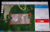
I wanted to try the survey mission in Tower. But no flight lines are displayed in the marked area and the flight altitude is marked with red. Max flight altitude is also limited to 100m.
Tower latest version and Android is used.
The same question has been asked together with a photo at google+ group DroidPlanner 2 Beta.
Any ideas?
Edit. I could upload photo. Six photos...